Hurricane Jeanne
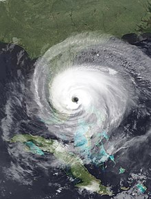 Hurricane Jeanne making landfall in Florida at peak intensity on September 26 | |
| Meteorological history | |
|---|---|
| Formed | September 13, 2004 |
| Extratropical | September 28, 2004 |
| Dissipated | September 29, 2004 |
| Category 3 major hurricane | |
| 1-minute sustained (SSHWS/NWS) | |
| Highest winds | 120 mph (195 km/h) |
| Lowest pressure | 950 mbar (hPa); 28.05 inHg |
| Overall effects | |
| Fatalities | 3,037 direct |
| Damage | $7.94 billion (2004 USD) |
| Areas affected | U.S. Virgin Islands, Puerto Rico, Dominican Republic, Haiti, Bahamas, Florida, Eastern United States |
| IBTrACS | |
Part of the 2004 Atlantic hurricane season | |
| General
Effects Other wikis | |
Hurricane Jeanne was the deadliest tropical cyclone in the Atlantic basin since Mitch in 1998, and the deadliest tropical cyclone worldwide in 2004. It was the tenth named storm, the seventh hurricane, and the fifth major hurricane of the season, as well as the third hurricane and fourth named storm of the season to make landfall in Florida. After wreaking havoc on Hispaniola, Jeanne struggled to reorganize, eventually strengthening and performing a complete loop over the open Atlantic. It headed westwards, strengthening into a Category 3 hurricane and passing over the islands of Great Abaco and Grand Bahama in the Bahamas on September 25. Jeanne made landfall later in the day in Florida just two miles (three kilometers) from where Hurricane Frances had struck a mere three weeks earlier.
Building on the rainfall of Frances and Hurricane Ivan, Jeanne brought near-record flood levels as far north as West Virginia and New Jersey before its remnants turned east into the open Atlantic. Jeanne is blamed for at least 3,006 deaths in Haiti with about 2,800 in Gonaïves alone, which was nearly washed away by floods and mudslides. The storm also caused 18 in the Dominican Republic, 8 deaths in Puerto Rico, and 5 in the rest of the United States, bringing the total number of deaths to at least 3,037, making Hurricane Jeanne one of the deadliest Atlantic hurricanes ever recorded. Final property damage in the continental United States was $7.5 billion, plus an additional $270 million in the Dominican Republic and $169.5 million in Puerto Rico.
Meteorological history
[edit]
Tropical storm (39–73 mph, 63–118 km/h)
Category 1 (74–95 mph, 119–153 km/h)
Category 2 (96–110 mph, 154–177 km/h)
Category 3 (111–129 mph, 178–208 km/h)
Category 4 (130–156 mph, 209–251 km/h)
Category 5 (≥157 mph, ≥252 km/h)
Unknown
Tropical Depression Eleven formed from a tropical wave 70 miles (110 km) east-southeast of Guadeloupe in the evening of September 13,[1] and was upgraded to Tropical Storm Jeanne the next day.[2] Jeanne passed south of the U.S. Virgin Islands on September 15,[3] making landfall near Yabucoa, Puerto Rico later the same day.[4] After crossing Puerto Rico, Jeanne reached hurricane strength on September 16 near the eastern tip of the Dominican Republic on the island of Hispaniola,[5] but fell back to tropical storm strength later that day as it moved across the mountainous island.[6] Jeanne moved offshore the Dominican Republic late in the afternoon of September 17.[7] By that time, Jeanne had weakened to tropical depression strength.[8] Even though Jeanne did not strike Haiti directly, the storm was large enough to cause flooding and mudslides, particularly in the northwestern part of the country.[9]
On September 18, while the system was being tracked near Great Inagua and Haiti, a new center formed well to the northeast and the previous circulation dissipated.[10] The system restrengthened, becoming a hurricane on September 20.[11] Jeanne continued to meander for several days (making a complete loop in the process) before beginning a steady westward motion toward the Bahamas and Florida.[9]
Jeanne continued strengthening as it headed west, passing over Great Abaco in the Bahamas on the morning of September 25.[12] Shortly thereafter, the hurricane reached Category 3 strength.[13] Jeanne maintained this intensity as it passed Grand Bahama Island. At 11:50 p.m. EDT on September 25 (0350 UTC September 26), Jeanne made landfall on Hutchinson Island, just east of Sewall's Point, Florida; Stuart, Florida; and Port Saint Lucie, Florida, at Category 3 strength.[14] This is the same place Hurricane Frances struck Florida three weeks earlier.[9][15]
Jeanne's track continued to follow within 20 miles (32 km) of that of Frances until it reached Pasco County.[16] The cyclone then swung more rapidly to the north, and the center remained over land all the way to the Georgia state line, unlike Frances which exited into the Gulf of Mexico. Jeanne became an extratropical cyclone over Virginia on September 28 and the system moved back into the Atlantic offshore the New Jersey coast the next day.[16]
Preparations
[edit]Puerto Rico
[edit]Hurricane Jeanne originated as a tropical depression on September 13 from a tropical wave, just east of the Lesser Antilles. At that time, the United States government issued a tropical storm warning for the entirety of Puerto Rico, about 43 hours prior to Jeanne making landfall on the island.[17] As it moved through the northeastern Caribbean Sea the storm steadily intensified and by late on September 14 Jeanne was forecast to move across the island as a minimal hurricane.[18] As a result, the tropical storm warning was upgraded to a hurricane warning. Ultimately, Jeanne made landfall at 1600 UTC on September 15 as a 70 mph (110 km/h) tropical storm, about 17 mi (27 km) east of Guayama.[17]
Prior to hitting, 3,629 people evacuated to 159 schools converted into emergency shelters.[19] Governor Sila María Calderón forbade the sale of alcohol during the storm. All ports around the island were closed,[20] and most flights were canceled.[21] Due to the threat for downed wires, the governor ordered for the entire island's power grid to be turned off during the storm. During Hurricane Hugo in 1989, six people were electrocuted to death, which influenced the decision. In addition, ferry trips from the main island to Vieques and Culebra stopped during the storm.[19]
In Vega Baja, an elderly man fell from a roof to his death while installing storm shutters.[22] As Jeanne moved ashore, an eye was in the process of developing, indicating winds near hurricane status,[23] although hurricane-force winds still affected higher elevations.[24] Jeanne quickly crossed Puerto Rico and eventually attained hurricane status in the Mona Passage between the island and Dominican Republic.[17]
Leeward Islands
[edit]On the morning of September 14, tropical storm warnings were issued for St. Kitts and Nevis, while tropical storm watches were issued for Anguilla. During the afternoon, tropical storm warnings were lowered for Saba, St. Eustatius, and St. Maarten, while hurricane warnings were issued for Puerto Rico and the U.S. Virgin Islands. Late on the morning of September 15, a hurricane watch was issued for the British Virgin Islands. That afternoon, tropical storm warnings were dropped for St. Kitts and Nevis, while hurricane warnings were lowered to tropical storm warnings for the U.S. Virgin Islands. On the evening of September 15, tropical storm warnings were dropped Puerto Rico and the U.S. Virgin Islands, while hurricane warnings were downgraded to tropical storm warnings for Puerto Rico, and all watches and warnings were dropped for the British Virgin Islands.[9] The entire power grid of Puerto Rico was shut down by the government of Sila María Calderón as the storm approached to prevent electrocutions and infrastructure damage.[25]
Hispaniola
[edit]
Tropical storm watches were issued from Cabrera to Isla Saona early in the afternoon on September 14. Later that afternoon, hurricane watches and tropical storm warnings were raised from Cabrera to Santo Domingo. Late in the morning of September 15, hurricane warnings were issued from Cabrera to Isla Saona, while hurricane watches and tropical storm warnings were raised from Cabrera to Puerto Plata. That evening, hurricane warnings were extended westward from Cabrera to Puerto Plata while hurricane watches and tropical storm warnings were issued from Puerto Plata to Monte Cristi. Late in the morning of September 16, tropical storm warnings were issued from Môle-Saint-Nicolas to Puerto Plata. That afternoon, hurricane warnings were downgraded to tropical storm warnings from Puerto Plata to Isla Saona while all hurricane watches were dropped. Late on the afternoon of September 17, tropical storm warnings were dropped for the remainder of Hispaniola.[9]
Bahamas
[edit]In the Bahamas, the first hurricane watch was issued at 2100 UTC on September 15 and included Acklins and Crooked Islands, Inagua, Mayaguana, Ragged Island, and Turks and Caicos Islands. By 1500 UTC the next day, that hurricane watch was upgraded to a hurricane warning. Simultaneously, another hurricane watch became in effect for Cat Island, Exuma, Long Island, Rum Cay, and San Salvador. The hurricane warning was downgraded to a tropical storm warning at 2100 UTC on September 17, while the hurricane watch was lowered to a tropical storm watch. Both the tropical storm warning and tropical storm watch were discontinued at 1000 UTC on September 19.[9]
Although Jeanne then tracked away from the Bahamas, the storm was threatening the archipelago again by September 23. As a result, the tropical storm watch for Cat Island, Exumas, Long Island, Rum Cay and San Salvador was resulted at 0900 UTC. A hurricane watch was then issued for the northwestern Bahamas by 1730 UTC on September 23. Around 0900 UTC the next day, a hurricane warning was posted for Abaco Islands, Andros Islands, Berry Islands, Bimini, Eleuthera, Grand Bahama Island, and New Providence, while a tropical storm watch was simultaneously issued for Cat Island, Exumas, Long Island, Rum Cay, and San Salvador. Late on September 25, the tropical storm warning was canceled. Early on the following day, the hurricane warning was downgraded to a tropical storm warning for Abaco Islands, Berry Islands, Bimini and Grand Bahama Island, while the remaining portion – Andros Islands, Eleuthera and New Providence – was discontinued. All tropical cyclone warnings and watches were canceled by 0900 UTC on September 26.[9]
Because Hurricane Frances struck only about two week prior, numerous houses were still patched with plastic sheeting on their roofs, while other residents were still living with neighbors or relatives. Officials urged residents in low-lying homes to evacuate. Shelters were set up at the churches and schools on Abaco Islands, Eleuthera, Grand Bahama. At least 700 people went to a shelter in Abaco Islands alone.[26]
Florida
[edit]Preparations in Central Florida were rushed and sudden, as it did not become apparent that the storm would make a direct hit until the morning of the 23rd.[27] Indeed, it had appeared the storm would pass safely offshore just the night before.[28] Voluntary evacuations were advised on Thursday and Friday, plans for opening shelters on Saturday were distributed to the public, and Florida Power and Light warned that power could be out "for an extended period of time".[29] Canals were also drained on the same day.[29]
On Friday, the Palm Beach Zoo prepared for the storm by moving small animals and birds into buildings such as restrooms and restaurants.[30] Evacuations began in earnest, with many residents leaving for the Keys, noting that the islands were the only location definitely out of harm's way. For once, evacuation to the Keys made sense.[31]
The center of Jeanne's eye achieved landfall near Stuart, at virtually the identical spot that Frances had come ashore three weeks earlier, the first time in record keeping that a hurricane made landfall in the same place as a previous storm of the same season. Maximum winds at the time of landfall were estimated to be near 120 mph (193km/h).[32]
Impact
[edit]| Country | Total | |
|---|---|---|
| Dominican Republic | 18 | |
| Haiti | 3,006+ | |
| United States | Puerto Rico | 8 |
| Florida | 3 | |
| South Carolina | 1 | |
| Virginia | 1 | |
| Total: | 3,037+ | |
| Because of differing sources, totals may not match. | ||
Guadeloupe
[edit]In its early states, Jeanne dropped heavy rainfall in Guadeloupe, peaking at 11.81 inches (300 mm).[33] The communes of Bouillante, Deshaies, and Pointe-Noire were the hardest hit. In Bouillante, 60 homes were damaged. The storm ruptured water pipes in the city of Bois Malher, isolating about 1,000 people. Damage to businesses resulted in 30 employees being laid-off. Crops also suffered impact, especially bananas. At the Malendure resort, which is located along the coast, the pier, restaurants, and dive base were rendered unusable. In Deshaies, 110 homes were severely damaged, including 60 in the city of Ferry. About a dozen boats were beached or capsized. Many roads and bridges were inflicted with damage.[34]
In Point-Noire, nearly 300 single-family homes were damaged or demolished. Three bridges were destroyed, while numerous roads were also affected. Further south in Vieux-Habitants, roads also suffered damage, particularly in the Beaugendre area, leaving a dozen households isolated. A primary school was impacted beyond repairs. In Saint-François, a trench was dug along a major highway to prevent a residential subdivision from flooding.[34]
Puerto Rico
[edit]
Upon making landfall near Maunabo midday on September 15,[35] Jeanne produced tropical storm force winds in portions of the island.[32] A NWS employee reported sustained winds of 63 mph (101 km/h), with gusts to 71 mph (114 km/h) in Salinas along the southern coast.[36] In Cayey, located in the center of the island, a 72 mph (116 km/h) gust was reported, just shy of hurricane force. Additionally, the Luis Muñoz Marín International Airport in San Juan reported sustained winds of 49 mph (79 km/h).[17] In Yabucoa, the winds killed one woman after she was flung into a wall.[37]
Most of Jeanne's impact came from its rainfall. The heaviest precipitation fell on the island Vieques with a total of 23.75 in (603 mm) in three days.[17][37] There, a 24‑hour total of 14.75 in (375 mm) was reported, a 1 in 100 year event.[37] On the Puerto Rican mainland, the rainfall averaged from 5–15 in (130–380 mm),[17] peaking at 19.2 in (490 mm) at Aibonito in the center of the island.[38] At that station, the rainfall reached 15 in (380 mm) in a 24‑hour period, surpassing a 1 in 100 year event. Heavy rainfall also fell on the offshore island of Culebra.[37] The heavy rainfall caused severe flooding along many rivers of Puerto Rico,[17] forcing 3,629 people to evacuate their houses in flood zones. The one and only flood-related death occurred when a person drowned in the Culebrinas River in Moca. Across the island, Jeanne produced mudslides and landslides and left $8 million in damage (2004 USD) to the water system;[37] about 600,000 people were left without running water.[39]
Throughout Puerto Rico, Jeanne heavily damaged schools, houses, businesses.[37] Strong wind gusts left 70% of the island without power,[40] and damage to the electrical grid totaled $60 million (2004 USD). The combination of fallen trees, landslides, and debris closed 302 roads and left many bridges damaged.[37] 400 people had to evacuate near the Río Grande de Añasco.[41] The storm left heavy crop damage in the southern and eastern portion of the island, particularly to coffee, plantain, banana, and wheat crops.[37] In Jayuya, the storm destroyed 30% of the coffee crop.[40] Of the $101.5 million crop damage total, more than half was from the banana crop. Overall, more than 15,500 acres (63 km2; 24.2 sq mi) of croplands were affected.[37]
Overall, Jeanne killed four people directly and another four indirectly in Puerto Rico; damage totaled $169.5 million (2004 USD),[42][43] making it the most damaging tropical cyclone since Hurricane Georges in 1998.[44][45]
Haiti
[edit]This section needs expansion. You can help by adding to it. (September 2024) |
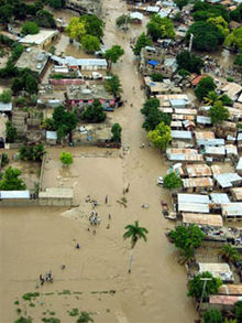
By September 17, heavy rains totaling about 13 in (330 mm) in the northern mountains of Haiti caused severe flooding and mudslides in the department of Artibonite, causing particular damage in the coastal city of Gonaïves, where it affected about 80,000 of the city's 100,000 residents. As of October 6, 2004 the official report counted 3,006 people dead, with 2,826 of those in Gonaïves alone.[46] Another 2,601 people were injured.
Decades of deforestation left surrounding valleys unable to hold the 30 hours of rain from Hurricane Jeanne, causing massive landslides. Aid trucks were forced to ford floodwaters and mudslides on National Route 1. In addition, the flooding destroyed all of the rice and fruit harvest in the Artibonite which has been regarded as "Haiti's breadbasket". Some residents had buried unclaimed corpses in their backyards. There were also mass burials of bodies tipped into a massive pit from dump trucks, despite objections to their ceremonious nature and discouragement from the World Health Organization, due to the popular but incorrect belief that dead bodies would lead to catastrophic outbreaks of exotic diseases.[47]
Dominican Republic
[edit]This section needs expansion. You can help by adding to it. (September 2024) |
In the Dominican Republic, the storm dumped torrential flooding rains and killing over two dozen.[48] Damage totaled $270 million (2004 USD).[49]
United States
[edit]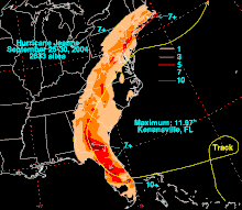
Millions in Florida were left without electricity, some for the third time in a month. There were five direct deaths in the mainland United States, three in Florida, one in South Carolina and one in Virginia. The final US damage was determined to be around $7.5 billion. It was difficult to isolate this from damage caused by Hurricane Frances (and, around Polk County and Highlands County, from Hurricane Charley as well).
As the storm moved northward east of the Appalachian Mountains, it continued producing heavy rains and flash flooding. Rainfall exceeded 6.00 inches (150 mm) as far north as New Jersey and Pennsylvania,[50] resulting in severe flash flooding in Philadelphia, Pennsylvania and its Pennsylvania and New Jersey suburbs on September 28. Tornadoes also touched down in Wilmington, Delaware and Cherry Hill, New Jersey.
Delaware and Maryland
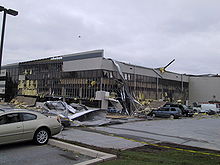
[edit]Throughout Delaware, the remnants of Jeanne produced between 4 and 8 in (100 and 200 mm) of rain,[51] peaking at 7.1 in (180 mm) at the University of Delaware.[50] This led to widespread street flooding and several rivers overflowed their banks. Forty people had to be rescued from a bus along the White Clay Creek after the creek crested at .59 ft (0.18 m) above flood-stage.[51] A strong F2 tornado touched down in the state, injuring five people and leaving $1 million in damages. The tornado touched down in northern New Castle County and tracked for 5 mi (8.0 km) and generated winds up to 130 mph (210 km/h). The county airport sustained significant damage, five C-130 cargo planes were damaged, thousands of pounds of jet fuel spilled, and damaged hangars. At a nearby industrial park, metal siding was torn off buildings, windows were shattered and power lines were downed. A self-storage facility sustained substantial damage.[52]
In Maryland, Jeanne produced up to 4 in (100 mm) of rain,[50] triggering flash flooding throughout the state.[53] Numerous roads were flooded,[54] including parts of Maryland Route 17.[55] Several rivers rose above their flood-stage, with the Big Elk Creek cresting at 9.3 ft (2.8 m), 0.3 ft (0.091 m) above food-stage.[56] A total of 50 roads were closed due to high water throughout the state. Numerous reports of stranded vehicles were sent to the Emergency Operations Center. In Carroll County, a group of inmates required rescue after the jail they were in flooded.[57] One brief F0 tornado touched down in the state near Solomons, causing minor damage.[58]
Florida
[edit]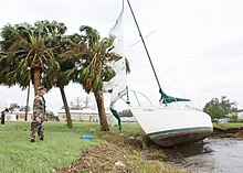
Two tornadoes were spawned by Hurricane Jeanne in Brevard County, both of which tracked through Micco and were of F1 intensity on the Fujita scale. The first tornado moved through a mobile home community, though damage was mainly to trees which were knocked over.[59] In contrast, the second destroyed several mobile homes, resulting in $350,000 (2004 USD) in damage.[60] High winds were reported in the county, with wind gusts of 91 mph (146 km/h) recorded at the National Weather Service Office in Melbourne. Furthermore, it is estimated that wind gusts in excess of 115 mph (185 km/h) occurred in the southern portions of the county.[61] Throughout the county, rainfall was mostly between 6 and 8 inches (150 and 200 mm), which flooded streets and roads in the Palm Bay area. In addition, a man in Palm Bay drowned after driving his car into a flooded ditch.[62] Damage in Brevard County was estimated at $320 million (2004 USD).[61]
High winds also significantly affected Lake County. The highest wind sustained wind speed reported was 47 mph (76 km/h) in Leesburg, though gusts to hurricane force intensity were observed in the southern portion of the county. At least 2,800 homes were damaged, 111 of which were destroyed. One fatality occurred after a 91-year-old woman died in a fire, which was started by a candle lit in her home. Damage in Lake County totaled to $8 million (2004 USD), while an additional $8.2 million in loses occurred to the citrus and nursery industry.[63]
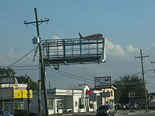
In Orange County, high winds were also reported, with a gust to 76 mph (122 km/h) recorded at the Orlando International Airport. Throughout the county, extensive damage occurred to houses, businesses, and public buildings. Overall, damage was estimated at $40 million (2004 USD).[63]
In Osceola County, hurricane-force wind gusts damaged or destroyed several homes, resulting in $11 million (2004 USD) in damage.[63] Precipitation in the county peaked at 11.97 inches (304 mm) in Kenansville, which was the highest rainfall total associated with Hurricane Jeanne.[64] Due to heavy rainfall, flash flooding was reported, especially in the northern portions of the county. Streets and roads along U.S. Route 192 were inundated in the vicinity of St. Cloud.[65] Damage to agriculture was also significant, totaling to an $8 million (2004 USD).[63]
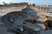
Although the storm made landfall well to the south, Indian River County was severely affected due to the right eyewall passing through.[61] One F1 tornado was spawned by the Jeanne in Vero Beach. It moved near the intersection of Florida State Road 60 and Interstate 95, where it felled numerous trees, resulting in approximately $20,000 (2004 USD) in damage.[66] Rainfall in the county was mostly between 6 and 8 inches (150 and 200 mm), which flooded streets and roads, especially in Vero Beach.[67] The highest wind gusts in Indian River County were 122 mph (196 km/h) at Vero Beach and 116 mph (187 km/h) in Sebastian. As a result of strong winds, more than 49,300 houses were either damaged or destroyed.[61] An elderly woman was injured while evacuating her home; she died from her injuries a few days later.[17] Damage was severest in Indian River County, with estimates of losses in excess of $2 billion (2004 USD).[61]
To the south in St. Lucie County, Jeanne produced tides at an estimated height of 10 feet (3.0 m) above normal.[68] As a result of high tides, marinas were damaged at the Fort Pierce Inlet, which, in turn, destroyed numerous boats. A private residence near the Fort Pierce Inlet recorded a wind gust of 128 mph (206 km/h). Throughout the county, high winds damage or destroyed thousands of homes and businesses, as well as several mobile home communities. One man was injured when he ran his truck over a downed power line. In St. Lucie County, damage was extensive, albeit less than Indian River County, with estimates totaling to $1.2 billion (2004 USD).[61]
Although the storm made landfall in Martin County, affects were less severe in comparison to the counties immediately north.[61] Along the coast of Martin County, tides were estimated to be up to 8 feet (2.4 m).[68] High winds also affected the county, with a wind gust of 105 mph (169 km/h) reported in Jensen Beach. Overall, more than 4,180 homes were either damaged or destroyed. No fatalities occurred in Martin County, and no damage figures exist.[61]
In northern Palm Beach County, storm surge was mainly between 2 and 4 feet (0.61 and 1.22 m). 591,300 customers in Palm Beach County were left without electricity. Damage in Palm Beach County totaled to $260 million (2004 USD).[citation needed]
Hurricane Jeanne also affected areas Miami-Dade County, albeit less severely. At Fowey Rocks Light, the C-Man station recorded maximum sustained winds of 49 mph (79 km/h) and gusts to 59 mph (95 km/h). Winds were much lighter inland, with sustained winds reaching 29 mph (47 km/h) and gusts as high as 36 mph (58 km/h) at Miami International Airport. Rainfall was considerably lighter in Miami-Dade County in comparison to the counties north, with precipitation amounts average between 0.5 and 1 inch (13 and 25 mm). Overall, 25,100 power outages were reported and damage totaled to $10 million (2004 USD).[69] A National Football League game between the Pittsburgh Steelers and Miami Dolphins was delayed by 7 hours and 30 minutes because of the storm.[70]
Effects from Hurricane Jeanne were reported as far south as Monroe County. The highest winds gusts in the county were 51 mph (82 km/h) at the Sombrero Key Light C-Man Station and 49 mph (79 km/h) at the Molasses Reef C-Man Station. Storm tides were 1 foot (0.30 m) above normal on Vaca Key; it is estimated that tides reaching 2.5 feet (0.76 m) above average occurred near North Key Largo. The surge of water inundated a parking lot at the Jewfish Creek Bridge. Due to spring tides and elevated waters in Florida Bay, minor tidal flooding occurred at the Key West International Airport. Property damage was minor, totaling to only $5,000 (2004 USD).[71]
Aftermath
[edit]Puerto Rico
[edit]Following the passage of the storm, two people died due to carbon monoxide poisoning after running a generator in closed space without proper ventilation. Two others died and another was injured when a tree damaged by winds fell onto their car near Yauco.[37] Due to contaminated water supplies, authorities advised people to boil water before consumption.[40] In the day after the storm's passage, electric companies restored power to all but 870,000 people. Most of the western portion of the island was repaired first, as were hospitals and the Luis Muñoz Marín International Airport.[19]
On September 17, two days after Jeanne struck, United States President George W. Bush declared Puerto Rico a disaster area,[72] which provided for the cost of debris removal and emergency services.[73] In the immediate aftermath, the Federal Emergency Management Agency (FEMA) funded crisis counseling services for storm victims, set up by the Puerto Rico Department of Health/ Mental Health and Anti-Addiction Services Administration.[74] After the storm's passage, FEMA established six disaster recovery centers.[75] Ultimately, more than 206,000 people applied for disaster assistance, including grants for essential repairs and temporary housing. FEMA approved the request for 155,933 people, providing $401.1 million in aid.[76] In March 2005, the US Government provided $14.6 million in aid for reconstruction projects, including repairs to the power grid, as well as general road and bridge restoration.[77]
Due to its damage along its path, Hurricane Jeanne was retired by the World Meteorological Organization in Spring 2005, meaning the name will never be used again for an Atlantic hurricane.[78] The name was replaced by Julia which was used during the 2010 season.[79]
Retirement
[edit]As a result of the hurricane's impact, the name Jeanne was retired from the rotating lists of tropical cyclone names in the spring of 2005 by the World Meteorological Organization, and will never again be used for an Atlantic basin tropical cyclone.[80] It was replaced with the name Julia for the 2010 season.[81]
See also
[edit]- List of Category 3 Atlantic hurricanes
- List of Florida hurricanes (2000–present)
- List of natural disasters in Haiti
- Timeline of the 2004 Atlantic hurricane season
- Hurricane Erin (1995) – a Category 2 hurricane that made landfall in Central Florida and the Florida panhandle, causing moderate damage
- Hurricane Nicole (2022) – a Category 1 hurricane that took a near identical track through The Bahamas and Florida in mid-November
References
[edit]- ^ Stacey Stewart (2004). Tropical Depression Eleven Public Advisory Number 1. National Hurricane Center. Retrieved on 2009-04-16.
- ^ Stacey Stewart (2004). Tropical Storm Jeanne Public Advisory Number 4. National Hurricane Center. Retrieved on 2009-04-16.
- ^ Rick Knabb and Brian Jarvinen (2004). Tropical Storm Jeanne Public Advisory Number 7. National Hurricane Center. Retrieved on 2009-04-16.
- ^ Jack Beven (2004). Tropical Storm Jeanne Public Advisory Number 8. National Hurricane Center. Retrieved on 2009-04-16.
- ^ Brian Jarvinen (2004). Tropical Storm Jeanne Public Advisory 11. National Hurricane Center. Retrieved on 2009-04-16.
- ^ James Franklin (2004). Hurricane Jeanne Public Advisory Number 13. National Hurricane Center. Retrieved on 2009-04-16.
- ^ Miles B. Lawrence (2004). Hurricane Jeanne Public Advisory Number 16A. National Hurricane Center. Retrieved on 2009-04-16.
- ^ Miles B. Lawrence (2004). Hurricane Jeanne Public Advisory Number 17. National Hurricane Center. Retrieved on 2009-04-16.
- ^ a b c d e f g Miles B. Lawrence and Hugh D. Cobb (2005). NHC Tropical Cyclone Report: Hurricane Jeanne - 13-28 September 2004. National Hurricane Center. Retrieved on May 22, 2015.
- ^ Lixion Avila (2004). Hurricane Jeanne Discussion Number 21. National Hurricane Center. Retrieved on 2009-04-16.
- ^ Stacey Stewart (2004). Hurricane Jeanne Public Advisory Number 29. National Hurricane Center. Retrieved on 2009-04-16.
- ^ Lixion Avila (2004). Hurricane Jeanne Public Advisory Number 47A. National Hurricane Center. Retrieved on 2009-04-16.
- ^ Lixion Avila (2004). Hurricane Jeanne Public Advisory Number 28. National Hurricane Center. Retrieved on 2009-04-16.
- ^ Richard Pasch (2004). Hurricane Jeanne Discussion Number 50. National Hurricane Center. Retrieved on 2009-04-16.
- ^ Floods, floating coffins left in Jeanne's wake. Retrieved on 2009-04-16.
- ^ a b "Atlantic hurricane best track (HURDAT version 2)" (Database). United States National Hurricane Center. April 5, 2023. Retrieved December 28, 2024.
 This article incorporates text from this source, which is in the public domain.
- Landsea, Chris (April 2022). "The revised Atlantic hurricane database (HURDAT2) - Chris Landsea – April 2022" (PDF). Hurricane Research Division – NOAA/AOML. Miami: Hurricane Research Division – via Atlantic Oceanographic and Meteorological Laboratory.
- ^ a b c d e f g h Miles B. Lawrence and Hugh D. Cobb (January 7, 2005). "Hurricane Jeanne Tropical Cyclone Report". National Hurricane Center. Retrieved May 22, 2015.
- ^ Stacy Stewart (September 14, 2010). "Tropical Storm Jeanne Discussion Five". National Hurricane Center. Retrieved December 18, 2010.
- ^ a b c Various News Agencies (2004). "Most Of Island Remains In The Dark". Puerto Rico Herald. Archived from the original on March 29, 2012. Retrieved December 28, 2010.
- ^ Manuel Ernesto Rivera (September 16, 2004). "Jeanne Unleashes Flooding". Milwaukee Journal Sentinel. Associated Press. Retrieved December 18, 2010.
- ^ Staff Writer (September 16, 2004). "Tropical Storm Jeanne Batters Puerto Rico, Kills Two". Toledo Blade. Associated Press. Retrieved December 28, 2010.
- ^ Staff Writer (September 16, 2004). "Jeanne Kills 2 in Puerto Rico". Kentucky New Era. Associated Press. Retrieved December 23, 2010.
- ^ Jack Beven (September 15, 2010). "Tropical Storm Jeanne Discussion Nine". National Hurricane Center. Retrieved December 18, 2010.
- ^ Jack Beven (September 14, 2010). "Tropical Storm Jeanne Discussion Eight". National Hurricane Center. Retrieved December 18, 2010.
- ^ National Climatic Data Center (2005). September 2004 Storm Data. NOAA. Retrieved on 2007-02-15.
- ^ "Hurricane Jeanne Hits Abaco Island". Boca Raton News. Freeport, Bahamas. Associated Press. September 26, 2004. Retrieved June 1, 2014.
- ^ Eliot Kleinburg and Mary McLachin (2004). Not Again! Archived 2008-10-11 at the Wayback Machine Palm Beach Post. Retrieved on 2009-04-16.
- ^ Lixion Avila (2004). Hurricane Jeanne Discussion Number 38. National Hurricane Center. Retrieved on 2009-04-16.
- ^ a b Eliot Kleinberg, Mary McLachlin (2004). Region starts getting ready. Palm Beach Post. Retrieved on 2009-04-16.
- ^ Tim O'Meilia (2004). Zoo animals moved to emergency quarters. Palm Beach Post. Retrieved on 2009-04-16.
- ^ Jane Musgrave (2004). For once, evacuation to Keys makes sense to some. Palm Beach Post. Retrieved on 2009-04-16.
- ^ a b National Hurricane Center (2006). Hurricane History. Archived 2006-07-09 at the Wayback Machine Retrieved on 2009-04-16.
- ^ Twenty-Seventh Session RA IV Hurricane Committee (PDF) (Report). San José, Costa Rica: World Meteorological Organization. April 2005. p. 56. Archived from the original (PDF) on September 27, 2012. Retrieved June 1, 2014.
- ^ a b "Lourd bilan des intempéries" (in French). MAXImini.com. September 17, 2004. Archived from the original on October 15, 2014. Retrieved June 1, 2014.
- ^ National Weather Service Forecast Office, San Juan, Puerto Rico (2008). Tropical Storm Jeanne Across the U.S. Virgin Islands and Puerto Rico via the Internet Wayback Machine. Retrieved on 2009-04-16.
- ^ San Juan, Puerto Rico National Weather Service (January 21, 2009). "Tropical Storm Jeanne moves across the U.S. Virgin Islands and Puerto Rico". National Oceanic and Atmospheric Administration. Retrieved December 18, 2010.
- ^ a b c d e f g h i j National Climatic Data Center (2004). "Event Report for Puerto Rico". National Oceanic and Atmospheric Administration. Archived from the original on June 13, 2007. Retrieved December 22, 2010.
- ^ David X. Roth (December 30, 2006). "Rainfall Summary for Hurricane Jeanne". Hydrometeorological Prediction Center. Retrieved December 22, 2010.
- ^ National Climatic Data Center (October 2004). "State of the Climate: Global Hazards for September 2004". National Oceanic and Atmospheric Administration. Retrieved December 22, 2010.
- ^ a b c "Tropical Storm Jeanne Spins Through Caribbean". Gettysburg Times. Associated Press. September 18, 2004. Retrieved December 28, 2010.
- ^ National Weather Service Forecast Office, San Juan, Puerto Rico (2007). Tropical Storm Jeanne: Hydrologic Summary for Puerto Rico and the U.S. Virgin Islands via the Internet Wayback Machine. Retrieved on 2009-04-16.
- ^ "Puerto Rico Event Report: Tropical Storm". National Climatic Data Center. National Oceanic and Atmospheric Administration. 2004. Archived from the original on December 21, 2021. Retrieved December 21, 2021.
- ^ "Puerto Rico Event Report: Tropical Storm". National Climatic Data Center. National Oceanic and Atmospheric Administration. 2004. Archived from the original on December 21, 2021. Retrieved December 21, 2021.
- ^ National Climatic Data Center (2010). "Hurricane Events in Puerto Rico". Retrieved December 28, 2010.[permanent dead link]
- ^ National Climatic Data Center (2010). "Hurricane Events in Puerto Rico". Retrieved December 28, 2010.[permanent dead link]
- ^ USAID (2007). Hurricane relief. Archived 2004-10-15 at the Wayback Machine Retrieved on 2007-02-16.
- ^ "Hurricane Jeanne Over Haiti, 2004". September 28, 2004. Archived from the original on October 14, 2004. Retrieved July 15, 2017.
- ^ "Hurricane Jeanne Hammers Haiti and Florida". Archived from the original on October 19, 2004. Retrieved February 15, 2008.
- ^ World Meteorological Organization (2007). Twenty-Seventh Session RA IV Hurricane Committee via the Internet Wayback Machine. Retrieved on 2007-02-15.
- ^ a b c Roth, David M (May 12, 2022). "Tropical Cyclone Rainfall in the Mid-Atlantic United States". Tropical Cyclone Rainfall. United States Weather Prediction Center. Retrieved January 6, 2023.
 This article incorporates text from this source, which is in the public domain.
- ^ a b "Delaware Event Report: Flash Flood". National Climatic Data Center. 2004. Retrieved September 7, 2009.[permanent dead link]
- ^ "Delaware Event Report: F2 Tornado". National Climatic Data Center. 2004. Retrieved September 6, 2009.[permanent dead link]
- ^ "Maryland Event Report: Flash Flood". National Climatic Data Center. 2004. Retrieved September 7, 2009.[permanent dead link]
- ^ "Maryland Event Report: Flash Flood". National Climatic Data Center. 2004. Retrieved September 7, 2009.[permanent dead link]
- ^ "Maryland Event Report: Flash Flood". National Climatic Data Center. 2004. Retrieved September 7, 2009.[permanent dead link]
- ^ "Maryland Event Report: Flash Flood". National Climatic Data Center. 2004. Retrieved September 7, 2009.[permanent dead link]
- ^ "Maryland Event Report: Flash Flood". National Climatic Data Center. 2004. Archived from the original on May 20, 2011. Retrieved September 7, 2009.
- ^ "Maryland Event Report: F0 Tornado". National Climatic Data Center. 2004. Archived from the original on May 20, 2011. Retrieved September 7, 2009.
- ^ Stuart Hinson (2004). "Event Record Details: Tornado". National Climatic Data Center. Retrieved February 26, 2012.[permanent dead link]
- ^ Stuart Hinson (2004). "Event Record Details: Tornado". National Climatic Data Center. Retrieved February 26, 2012.[permanent dead link]
- ^ a b c d e f g h Stuart Hinson (2004). "Event Record Details: Hurricane/typhoon". National Climatic Data Center. Archived from the original on May 19, 2011. Retrieved February 26, 2012.
- ^ Stuart Hinson (2004). "Event Record Details: Flash Flood". National Climatic Data Center. Retrieved February 26, 2012.
- ^ a b c d Stuart Hinson (2004). "Event Record Details: Strong Winds". National Climatic Data Center. Retrieved February 25, 2012.
- ^ David M. Roth (December 30, 2006). "Hurricane Jeanne - September 25-30, 2004". Hydrometeorological Prediction Center. Retrieved February 25, 2012.
- ^ Stuart Hinson (2004). "Event Record Details: Flash Flooding". National Climatic Data Center. Retrieved February 25, 2012.
- ^ Stuart Hinson (2004). "Event Record Details: Tornado". National Climatic Data Center. Retrieved February 26, 2012.
- ^ Stuart Hinson (2004). "Event Record Details: Flash Flood". National Climatic Data Center. Retrieved February 26, 2012.[permanent dead link]
- ^ a b Stuart Hinson (2004). "Event Record Details: Storm Surge". National Climatic Data Center. Archived from the original on May 20, 2011. Retrieved March 12, 2012.
- ^ Stuart Hinson (2004). "Event Record Details: Hurricane/typhoon". National Climatic Data Center. Retrieved February 26, 2012.[permanent dead link]
- ^ NFL games affected by severe weather or natural disasters, NBC Sports Boston, December 16, 2022
- ^ Stuart Hinson (2004). "Event Record Details: Hurricane/typhoon". National Climatic Data Center. Retrieved February 26, 2012.[permanent dead link]
- ^ Federal Emergency Management Agency (2004). "Puerto Rico Tropical Storm Jeanne and Resulting Landslides and Mudslides". Archived from the original on April 9, 2010. Retrieved December 28, 2010.
- ^ Staff Writer (September 18, 2004). "Designated Federal Aid Mainly for Emergency Response in Puerto Rico". Federal Emergency Management Agency. Archived from the original on June 6, 2010. Retrieved December 28, 2010.
- ^ Staff Writer (October 29, 2004). "Aid To Help Tropical Storm Jeanne Victims Cope With Disaster-Related Stress". Federal Emergency Management Agency. Archived from the original on June 6, 2010. Retrieved December 28, 2010.
- ^ Staff Writer (October 11, 2004). "Weekly Summary". Federal Emergency Management Agency. Archived from the original on June 6, 2010. Retrieved December 28, 2010.
- ^ Staff Writer (February 3, 2005). "Weekly Summary". Federal Emergency Management Agency. Archived from the original on June 6, 2010. Retrieved December 28, 2010.
- ^ Staff Writer (March 16, 2005). "FEMA Approves More Than $14.6 Million For PREPA Projects". Federal Emergency Management Agency. Archived from the original on June 6, 2010. Retrieved December 28, 2010.
- ^ "Retired Hurricane Names Since 1954". National Hurricane Center. 2009. Archived from the original on June 28, 2011. Retrieved December 28, 2010.
- ^ "Worldwide Tropical Cyclone Names". National Hurricane Center. 2010. Archived from the original on September 2, 2010. Retrieved December 28, 2010.
- ^ "4 hurricanes in 6 weeks? It happened to one state in 2004". Washington, D.C.: NOAA. August 26, 2019. Retrieved April 11, 2024.
- ^ National Hurricane Operations Plan (PDF) (Report). Washington, D.C.: NOAA Office of the Federal Coordinator for Meteorological Services and Supporting Research. May 2010. p. 3-7. Retrieved April 11, 2024.
External links
[edit]- Hurricane Jeanne
- 2004 Atlantic hurricane season
- Category 3 Atlantic hurricanes
- Retired Atlantic hurricanes
- Hurricanes in Puerto Rico
- Hurricanes in the Dominican Republic
- Hurricanes in Haiti
- Hurricanes in Florida
- Hurricanes in Delaware
- Hurricanes in Virginia
- Hurricanes in Maryland
- Hurricanes in New York (state)
- Hurricanes in New Jersey
- Hurricanes in Pennsylvania
- Hurricanes in Washington, D.C.
- 2004 in the Caribbean
- 2004 in Haiti
- 2004 in the Dominican Republic
- 2004 natural disasters in the United States
- September 2004 events in North America
- September 2004 events in the United States

